Forrest County map (The locale of smaller communities and settlements are approximations)
While Forrest County's largest population is concentrated in the Hattiesburg-Petal area, smaller towns, settlements and communities dot the county map. Many of these population centers originated as farming communities in the 1800's.
Newer settlements in the form of lumber towns and railroad stops arose at the turn of the 20th century during the timber boom. Once trees were cleared from these forested regions, sawmills closed and workers either moved elsewhere, remained as farmers or found other local employment. Over time, these areas either became standalone municipalities, were assimilated into adjacent towns or simply vanished.
This gallery spotlights some of the Forrest County area's better documented settlements and communities. While the information is admittedly sketchy in some instances, our intent is to (a) acknowledge these historical sites and, where possible, (b) briefly describe their origin and role in shaping the county as we know it today.
Additional stories on many of the settlements listed below as well as other historical Forrest County sites such as Black Creek, Blue Jay Swimming Hole, Dixie Highway, Lake Geiger, Okatoma Creek and Greens Creek are included in The History of Forrest County Mississippi, copies of which are available through our Gift Shop.
Please contact us if you have any information on historical Forrest County settlements.
(Click a View button for additional information and a photo.)
Currently located in Lamar County as a northwest Hattiesburg neighborhood, Arnold Line was originally a branch railroad which served the sawmill owned by John Thomas Arnold. Owen Arnold purchased land just north of the road crossing during the operation of the John Thomas Arnold Mill.
With its reported mineral waters, Arnold Springs may have been on the 171 acres Owen purchased near Rawls and Mammoth Springs in Forrest County in 1896.
Source: The History of Forrest County, 2000; https://www.niche.com/places-to-live/arnold-line-lamar-ms/
The nursery was established by the U.S. Forest Service in 1935-1936 and was named for William W. Ashe, an authority on logging costs, forest economics, erosion, forest types and the taxonomy of woody plants of the southeastern United States.
Located approximately 3 miles southeast of Brooklyn on Ashe Nursery Road, the nursery played an important role in the reforestation of cut-over lands in Forrest County and the revival of the county's timber industry.
Source: The History of Forrest County Mississippi, 2000.
Also known as Barronville, the community lies in east Petal and was named after J. O. Barron, owner of Hattiesburg's Barron Motor Company in the early 1900's. The original cutover land was divided into lots and homes were built and sold to area residents.
Located in south Hattiesburg, the Bonhomie Community is the former site of the Tatum Lumber mill. The Bonhomie name is credited to unemployed men from New Orleans and the Gulf Coast who referred to Mr. Tatum as a good man who hired them to work at his mill. "Bon Homme" is French for "good man."
Originally named "Bullis" after a construction engineer, the town's post office began operation under the "Brooklyn" name in 1897. The town once hosted three lumber mills and a variety of stores. Located south of Hattiesburg near Highway 49, it is currently home to the Forrest County Agricultural High School and the South Forrest Attendance Center.
Girl Scouts pose in front of their Camp Dantzler cabin (c)1946
Around 1895, The Camp Dantzler area was home to the L. N. Dantzler logging mill. The small town of Howison sprang-up next to the mill. Howison became a ghost town after the late 1920's when the mill moved to Perkinston.
With proximity to Black Creek, Camp Dantzler often served as a camping and recreation center for the Boy Scouts, the Girl Scouts, the YMCA and the YWCA.
Source: De Soto National Forest, Mississippi, 1997 by Robert E. Reams, Archaeologist;
https://www.passportintime.com/camp-dantzler.html; The History of Forrest County Mississippi, 2000
The Carnes community, named after early settler John Carnes, is located in southern Forrest County. It was settled in 1905 and was originally named Helena.
Carnes is located on the former Gulf and Ship Island Railroad. It was once home to two pine lumber mills and the Red Creek Lumber Company. A post office operated under the Carnes name from 1905 to 1934.
Forrest County Agricultural High School entrance
Currie was a farming community established in 1912. Located one mile north of Brooklyn on the G&SI Railroad, it was named for Reverend E. J. Currie, a Presbyterian minister, who established his school there. The area was assimilated into the town of Brooklyn which today serves as home to the FCAHS (Forrest County Agricultural High school).
Sources: Hometown Mississippi by Breiger (p. 135), A Study of Place Names in Forrest County, MS by Jack Alan Smith (p. 84), Hattiesburg American, March 31, 1985 p. 1
The Dixie community is located south of Hattiesburg. Its beginnings pre-date Hattiesburg's incorporation and initially consisted of small homesteads and widely scattered farms.
The area is currently home to Forrest County's Dixie Attendance Center (grades K-8) that was established in 1921. While the main campus is a modern facility, an historical marker commemorates the new site of the center's original log cabin that was built in the early 1930's and refurbished in the 1990's.
Dixie Pine is located in southeast Hattiesburg on James Street, north of the Bobby Chain Municipal Airport. It was named for the Dixie Pine Products Company which was located in the area.
The company, founded by the Dreyfus family in 1928, originally produced naval stores until 1966 when manufacturing was limited to resin chemicals only. The railroad station that served the company was named Dreyfus.
Source: The History of Forrest County Mississippi, 2000
During the timber boom of the early 1900's, Dragon served as a loading yard where logs were transferred to flat cars using teams. The loading platform no longer exists, and the area has become a farming community. The region, which is still referred to as Dragon, is five miles northeast of Hattiesburg on the former Southern Railroad.
One source reports the name "Dragon" was originated by railroad workers who described the "hard drag" trains had due to the railroad grade.
Source: https://www.oocities.org/hattiesburg_history/forrest_county_history.html#early; Hub City Spokes, 2/7/19
Eastabuchie straddles Forrest and Jones Counties on Highway 11, approximately six miles north of the city of Petal. The area's name is part Indian and part English and is generally considered to mean "east of running water" (its location relative to the Leaf River). In earlier times, it is said that the Choctaw indians met in Eastabuchie for ceremonial dances and tribal functions.
The Eastabuchie Lumber Co., the primary employer in the area at the turn of the 20th century, closed in 1912.
Eatonville is a small, unincorporated community located north of Hattiesburg. It was originally a farming area in the early 1800's and was founded by settlers from Georgia and the Carolinas.
Eatonville currently serves as home to North Forrest County High Shool.
The area referred to as Epps was the original site of the J. P. Carter sawmill. The mill was sold to the J. F. Wilder Lumber Company in 1898 who employed some 300 workers. A small town sprung-up with services that included a school, church and post office.
The local post office (Epps) was named by a Mr. Wilder, though the reason for that particular name is not known. When timber was cleared from the area, the mill closed and the population dispersed. Mr. Wilder moved with his family to Hattiesburg in 1910 where lived until his death in 1923.
Located in the southeastern region of Forrest County, Fruitland Park was founded by John A. Nicholson in the late 1800's. Between 1900 and 1920, the community became part of an organized, though unsuccessful, effort to convert cutover pine forests into farms. Fruitland Park's historic New York Hotel operated between 1914 and 1919 and served as host to potential buyers of property in the planned community.
Fruitland Park currently serves as home to the Boy Scouts' Camp Tiak. Tiak is the Choctaw word meaning "tall pines."
Sources: SMG&HS, 8/2006; https://en.wikipedia.org/wiki/New_York_Hotel_(Fruitland_Park,_Mississippi); Jack Smith, A Study of Place-Names in Forrest County, Mississippi, 1969
Originally settled by Perry Jones as a farming community, Hickory Grove was renamed Glendale about 1910. It has developed into a residential area and is home to a variety of small businesses.
An area located just across the Leaf River from the suburbs of Hattiesburg, Harvey is southeast from Petal and almost due east from Hattiesburg. The community supports several small businesses. The land in that vicinity was once owned by Harvey Chappell; in his honor, the area is called "Harvey."
Located at the confluence of the Bouie and Leaf Rivers in what is now east Hattiesburg, Twin Forks was orignally settled by Choctaw Indians.
The region subsequently became known as Gordonville or Gordon Station (named after early settler William Scott Gordon) and eventually, Hattiesburg. Gordon's Creek runs through much of Hattiesburg and continues to serve as a major drainage channel for the area.
Source: Jack Smith, A Study of Place-Names in Forrest County, Mississippi, 1969
The Kelly Settlement was founded in 1802 by Irishman John (or Green) Kelly and his servant, Sarah. Kelly moved from either Georgia or Alabama and purchased 640 acres of land in north Forrest County between Eatonville, Glendale and Eastabuchie.
The settlement was home to the 1925-1958 Bay Springs School, a Rosenwald facility that educated African-Americans during segregation. No longer a school, the building was remodeled in 2012.
Tragically, the Kelly Settlement gained notoriety in 1966 when civil rights activist Vernon Dahmer, Sr. was killed in a firebomb attack on his home.
Lake View was a residential community situated behind the current Hattiesburg Convention Center. It was named for the artificial lake built in the 1920's by (then) Mayor W. S. F. Tatum.
Lake View Park was operated by the City until World War II. Also referred to as Riverside (former home of the Riverside Brick Company), the area provided residents with opportunities for swimming and fishing. Dances were held on the pavilion.
Source: SMGHS, 11/2008; The History of Forrest County Mississippi, 2000
The current Leeville neighborhood in the city of Petal began as a settlement founded by Green Berry and Julyan Lee. At its founding, the area featured abundant timber and was situated near a lake. It was also in proximity to Lee's parents who lived in nearby Monroe.
Leeville opened its one-room McKinnon School in 1897. It remained in operation until approximately 1922 when it was consolidated with Petal.
Located east of Barrontown on old Richton Road in Perry County, the community's name was thought to come from the Bible, Acts 16:9. The area once hosted a post office known as "Ideal."
Macedonia is also known as Tallahala, the name derived from nearby Tallahala Creek. "Tallahala" is derived from the Choctaw language and is thought to mean "standing rocks."
Source: The History of Forrest County, 2000; https://en.wikipedia.org/wiki/Tallahala,_Mississippi
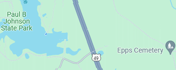
Mammoth Springs was located five miles north of Hattiesburg near the current intersection of I-59 and Hwy 49. The pure waters in the area were discovered in 1862 and became known for their medicinal qualities.
A Dr. Broomfield named the springs because of the strong flow of water. A health resort was established in the area in the late 1890's, though the resort is no longer in operation. The property was eventually sold to Dr. Tom Rhea Phillips, Jr.
Originally settled in 1896, the area was renamed Maxie in 1910 for Anna Maxie Fields whose husband owned the Pole Stock Lumber Company. Maxie is located in the southern portion of Forrest County in the DeSoto National Forest. It served as a stop on the G&SI railroad during the timber boom and was home to the Chancellor Lumber Company saw mill.
The area included a post office from 1900 to 1967; by 1964, its population had dwindled to 125. In 2019, the only remaining features with the Maxie name were a church and cemetery.
Sources: https://en.wikipedia.org/wiki/Maxie,_Mississippi; https://www.msgw.org/forrest/public_html/history/forrest.html; Jack Smith, A Study of Place-Names in Forrest County, Mississippi, 1969; https://mississippi.msghn.org/forrest/w_maxie.html
The Maybank community is located just north of Rawls Springs. It serves as the home of the Pep's Point summer resort. The area was named for May, the wife of the manager of the former J. C. Bryant sawmill which was located on the bank of the Bouie River. Maybank was also the location of the former Monroe railroad station.
Source: Jack Smith, A Study of Place-Names in Forrest County, Mississippi, 1969
The McCallum Community was established as a farming area around 1808 by Scottish-born Malcolm McCallum. Located approximately eight miles southeast of Hattiesburg, the area was originally part of Greene County at the time of its founding.
McCallum's son, John, founded Enon Presbyterian Church and was largely responsible for Enon High School, a renowned institution during pre-Civil War years; the church and school no longer exist.
"Enon" is the word "none" spelled backwards; it is said to have been adopted when the area's post office required a name, but "none" could be agreed upon by residents. The name may also be a biblical reference.
Sources: https://www.oocities.org/hattiesburg_history/forrest_county_history.html; Jack Smith, A Study of Place-Names in Forrest County, Mississippi, 1969
The McLaurin Community is located below Camp Shelby's south gate off of Highway 49. McLaurin appeared on maps in 1895. The community's namesake is unclear (either [a] Governor Anselm J. McLaurin or [b] Civil War General McLaurin or [c] G&SI Railroad president Cornelius J. McLaurin).
McLaurin thrived during the timber boom and again when World War II brought soldiers to nearby Camp Shelby in the 1940's. Today, McLaurin is primarily a residential area.
Source: Where in the World is McLaurin by June Collier (from an undated HAHS archived article)
In 1818, brothers John and Patrick Monroe purchased land near the present site of Hattiesburg just below the confluence of the Bowie and Leaf Rivers. The settlement (which no longer exists) was frequently referred to as "Old Monroe" as to avoid confusion with the early 1900's "Monroe railroad station" that was located in the present-day Maybank community.
Monroe Road has been cited as serving a noteworthy role in history, because it was the location where Andrew Jackson's troops rested prior to the Battle of New Orleans.
Sources: The History of Forrest County, MS, 2000, Jack Alan Smith; Hattiesburg American, Ben Lee, 11/8/1987
30. View Morriston (Mars Hill, Carlisle's Hill, McDonalds Hill)
Morriston Historical Marker
Located approximately 10 miles northeast of Hattiesburg, the area has gone by several names including Mars Hill, Carlisle's Mill, McDonalds Mill and, from 1862, Morriston.
An historical marker shows that F. M. Morris served as postmaster for the area during the late 1890's. The post office no longer exists, but the name is still used to refer to the locale.
Located in south Hattiesburg between James Street and Hwy 49, the community was settled in 1879 by a Mr. Palmer (first name unknown).
In the 1950's, Palmer's Crossing was home to the Embassy Club that hosted big-named performers such as B.B. King, James Brown and Fats Domino. After the Embassy Club burned in 1958, The Hi Hat Club continued the tradition of quality entertainment until it closed in 1993.
Palmer's Crossing served a pivotal role in the 1960's civil rights movement when the community welcomed out-of-state volunteers who opened Freedom Summmer schools to teach children about equality and their parents about voting rights.
Hattiesburg's neighboring city of Petal is named after Gladys Petal Polk whose father was postmaster in the early 1900's. The child died of diphtheria at the age of two; she's buried in Oaklawn cemetery.
Once a bedroom community of Hattiesburg, Petal became a stand alone municipality with its incorporation in 1974. The city is known for its top-ranking schools, friendly residents and wide range of recreational activities.
The Pine Hills Neighborhood is located in south Hattiesburg off of 28th Avenue. Formed in 1935, the original 25 homesteads were mini-farms consisting of a house, a garage, a storage room and a chicken house. Each home was white with green shutters, all with distinctive twin clay chimney caps.
Jo Moor was one of the first to purchase one of the homesteads in 1942 when the federal government decided to get out of the rental business. City services were provided to the neighborhood when it was annexed in later years.
Sources: The History of Forrest County Mississippi, 2000; HAHS Newsletter, Winter, 2015
Located in the southern portion of Forrest County, the area served as headquarters for the notorious Copeland Clan in by-gone days. The dense forest and sparsely settled region afforded shelter and protection to clan members.
Located near the Forrest-Perry County line off of U.S. 98, Ragland Hills is a 380 acre botanical forest that serves as home to 318 different/rare species of plants.
Originally deeded to William Ragland of Perry County in 1820, the land was eventually acquired by former Mississippi Lt. Governor Ragland Carter. The preserve eventually fell under the stewardship of the Carter-McSwain family.
The Rawls Springs community is located approximately 6.5 miles northwest of Hattiesburg near Hwy 49. It was settled in 1833 by Benjamin Rawles.
Like nearby Mammoth Springs, the early 1900's saw a hotel and health resort that took advantage of the healing mineral springs found in the area, though operations were closed by 1936.
Prior to the opening of the Rawls Springs post office in 1905, mail for the region was received at the Heckla post office that was opened in 1895; Heckla was the name given to the area by Choctaw settlers who originally discovered the springs while searching for cane.
Sources: SMGHS, 8/2009; Jack Smith, A Study of Place-Names in Forrest County, Mississippi, 1969; Hattiesburg American, 8/5/1973
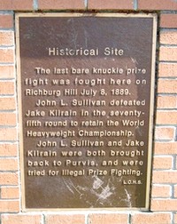
Located in southwest Hattiesburg in Lamar County, Richburg Hill is currently a residential community. The property was originally owned by C. W. Rich who served as Hattiesburg's mayor from 1901-1907 and 1911-1913.
In 1889, the area served as the site for the historic Sullivan-Kilrane bare-knuckle boxing match.
In 1908, the Richburg telegraph office transmitted news of the deadly Purvis tornado to the Hattiesburg train depot. Within hours, relief workers boarded the first of many trains with supplies that traveled to Purvis to aid victims.
Source: The History of Forrest County, 2000; https://www.hmdb.org/m.asp?m=118378; The Destruction of Purvis, Mississippi (undated article)
The Creek Lumber Co. played a prominent role in the history of this lumber mill town from 1903 to 1911. On December 30, 1910 the entire operation was sold to Thomas Carruth for $25,000. A year later, Carruth transferred the railroad equipment at Rosine to his other mill at Coral, Mississippi in Lamar County.
Rosine was located south of Epps and north of Brooklyn.
Sheeplo is generally located between Petal and the Indian Springs Community near the Perry County line. The first homestead was recorded by its founder, George Tisdale, in 1886.
The area's name references by-gone days when sheep wandered the region and (for unknown reasons) gathered nightly at a single location eventually called "Sheep Low."
As with many early settlements, Sheeplo was once a self-sufficient community that grew its own food and it had its own carpenters, plumbers and mechanics. In 1965, Sheeplo and Indian Springs residents formed a cooperative aimed at boosting farm productivity.
Sources: Hattiesburg American, 2/5/2006; https://www.msgw.org/forrest/public_html/history/forrest.html; The History of Forrest County Mississippi, 2000
Skull Fork, a community near Carnes, received its name after a drunken brawl that occurred in the area at a fork in the road. One fight participant's skull was broken with a whiskey bottle by his opponent. The names of the men involved are not known.
Located in south Petal, the Sunrise area includes residential subdivisions such as Pleasant Ridge Estates, Pecan Lakes and Reese Creeks.
The Sunrise School received its name through a simplification of its original name (The Rising Sun) by D. P. Meyers when the facility was moved from its first site near the present-day Batson Community.
Source: https://en.wikipedia.org/wiki/Petal,_Mississippi; The History of Forrest County Mississippi, 2000